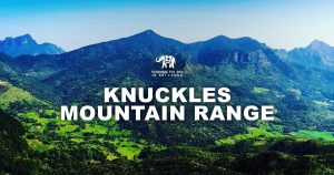


Knuckles forest as the English called it or “Dumbara” as early Sinhalese called it is an area spanning 21,000 hectares covering parts of Kandy and Matale districts.
These evergreen mountain ranges are visible from lowlands of Dambulla and highlands of Badulla. The forest reserve was aptly named by the uniquely shaped mountain range in the middle of it. Which resembles the shape of knuckles of a clenched fist.

Mist covered Knuckles mountain range.
It has been declared a world heritage site in 2010 by UNESCO as Knuckles Conservation Forest due to the high biodiversity and being home to numerous indigenous plants and animals.
Knuckles reserve is also adorned with breathtaking cascades strewn across all over the reserve such as Doowili Ella, Sera Ella, Knuckles falls to name a few.
You could spend months traveling in and around the thick forest and mist covered mountains exploring the known and unknown.
There are 33 identified mountains in the forest reserve and 2 out of these stands above 1,800 meters above MSL. The highest being “Gombaniya” (1,906m) and the second peak of Knuckles mountain range (1,864m) being a close second.
The Knuckles Range

The peaks of Knuckles range seen from Kotaganga camping site.
The Knuckles range has 05 peaks and it is the most climbed mountain range in the forest reserve. There are several trails leading to the top and frequented by local hikers and foreigners alike.
Do you need a guide?
One can hike the knuckles range without a guide if you follow the instructions mentioned in this article. If you’re in a decent physical condition, covering the range within a day is possible.
How to get there?
There are several trails leading to the summit but the most popular one is Bambarella. Here is how to access the trailhead.
Own/Hired Vehicle:
Reach Kandy and proceed to Wattegama via Katugastota – Madawala road. Proceed to Bambarella via Huluganga. The distance is 26 km through windy roads with amazing scenery. From Bambarella there is about 5 km to the trailhead. [Directions]
Alternative road: (via Gomera)
Just before you reach Bambarella there is side road branching away to the right with a name board “Laggala Estate”. Proceed down the road until you reach Katool Oya rest house. You may continue the hike from here. This way is shorter (2 km) than the Bambarella road.
Public transport:
Reach Kandy and catch a bus/train to Wattegama. Buses to Bambarella are available thence. Get off at the Bambarella bus stop and proceed to the trail via Knuckles Peak road.
There are shortcuts through the estates, don’t forget to ask the locals around. You can buy a limited amount of items from the shop in Bambarella but it’s better to get necessities from Kandy or Wattegama.

Starting the hike from Gomara can get you quicker to the trail-head than Bambarella.
The Trail

The trail-head to the peaks. 05 Peaks are covered in mist.
The trail starts to the right side of the concrete road and continues about 600 m on a flat terrain surrounded by sparsely vegetated area until you reach a junction.
Turn right off here to reach Knuckles Falls. This is the first water source you’ll find on the trek. This serene fall doesn’t have much of a base pool and you can go directly under the cascade and have a refreshing natural shower.

The Knuckles falls – The first water source on the trail.
Get back to the junction and proceed up the trail which would gradually start to show some elevation through low-level mountainous forests. Not far from the fall you’ll come across the stream that feeds Knuckles falls.
Fill up your bottles from these ultra-fresh cold waters emanating from the misty peaks, since this is the last water source you’ll come across until you reach the peak and get back.
You’ll need plenty of water when climbing the lofty peaks of the range and avoid dehydration and cramps.

An early section of the trail.
The trail proceeds through flat terrains and low-level vegetation to the campsite 01 which lies on a vast flat area. Knuckles peaks will loom ahead to your left, probably covered in mist while to the right side, slopes towards Kandy will be visible.
The trek continuous through the scenic low-level vegetation until you reach the campsite 02. From there onwards, the ascent gets tougher and tougher until you reach into a thick wooden canopy.
The trees are not tall but grown so close that you’ll have to bend down to avoid getting your head banged against millions of thick branches winding about like serpents. (oh! That reminds me, serpents have been seen on the trail, so be vigilant).
After an hour or so you’ll reach a rest area with wooden stamps where you can have a bite to eat and hydrate yourselves.

Through the thick mountain forest canopy.
Please be responsible enough to carry every piece of garbage with you at all times. This is a sensitive mountainous forest you’re treading on. Protecting it is of utmost importance.
The steep climb to the first peak begins and you won’t still see the peaks clearly due to the thick forest canopy.
The trek is treacherous with loose stones and soil. After must huff and puff you’ll reach a junction amidst the thick woods. Take the left to reach the peak. The right side one leads to Alugallena and Thangappuwa.

Steeper sections of the trail.
The trek is the steepest after this point. Take your time and be careful where you step on. The surrounding flora changes to that of a mountainous forest. The environment is just out of the world. There are boulders along the way upon which you can get a much-needed rest.
The first peak should loom ahead of you now to the right. After half an hour you’ll finally reach the first peak, though there is no viewpoint on the first peak.
Proceed to the second peak through the clearly marked path whence you’ll find the viewpoint which affords you 360-degree views all around the forest reserve. This is the highest point of the entire range.

Looking back from the 05th peak.
If you’re up to it, proceed through the barely marked trek towards the other peaks. There is an opening to the side of the rock bed. Mind you, leech protection is a must for you to proceed beyond the second peak.
Otherwise, you’ll be fending off all sorts of leeches rather than concentrate on the amazing sceneries the ridges provide.
The trek is not a clear-cut hence watch where you step. Even though the ridge is not narrow, the trek falls along the edge at some points so watch every step, especially there is mist.
Which, most of the time, is the case. There is no thick vegetation beyond the second peak and you can easily reach the 05th peak within an hour at most.
It is said that these treks caused by sambars but you’ll be very lucky to see one.
Tips for the hike
- Start early as possible if you intend to cover the whole range. It’ll take around 5-6 hrs to complete all 5 peaks if weather permits.
- Public transport is available to Bambarella from Wattegama and Kandy.
- Leech protection is a must regardless of the season. They are rampant, especially after the second peak. Here are some ways to protect from leeches.
- There are 02 water sources available, 01 at the Knuckles falls and a stream further up. Make sure to fill up by the stream for the peaks as there are no water sources hereafter. Water will be much needed when climbing the peaks to avoid dehydration and in turn cramps.
- Don’t overload backpacks. The weight is a crucial factor in tackling the steep slope reaching the first peak.
- There are 02 camping sites available on the trail from Bambarella. If you’re descending from Thangappuwa side, can make camp at the Kotaganga campsite.
Thanks a bunch for reading and hope it was helpful. If there are any queries or you just want to share your experience, please leave a comment and we’ll get back to you. Happy hiking.
Tags : Kunckles, Mountain Climbing