


It is hard to imagine a small country like Sri Lanka packs such a vast geological diversity. A few hours travel can make such a difference in climate and scenery.
Out of hundreds of peaks on this small island, I’ve put together a list of mountains and rocks that are allowed to climb.
Just Click on the respective column header to sort the table as you want.
| Peak | Height (m) | Difficulty | Nearest Town | District | Location |
|---|---|---|---|---|---|
| Uthuwankanda | 431 | Easy | Uthuwankanda | Kegalle | Google Maps |
| Kabbale Mt | 440 | Moderate | Udugama | Galle | Google Maps |
| Yahangala | 1,220 | Difficult | Ududumbara | Matale | Google Maps |
| Kehelpathdoruwegala | 1,529 | Moderate | Ududumbara | Matale | Google Maps |
| Great Western | 2,212 | Difficult | Talawakelle | Nuwara Eliya | Google Maps |
| Govinda hela | 558 | Moderate | Siyambalanduwa | Monaragala | Google Maps |
| Riverston Peak | 1,420 | Easy | Rattota | Matale | Google Maps |
| Peacock Hills | 1,518 | Easy | Pussellawa | Kandy | Google Maps |
| Alagalla | 1,140 | Moderate | Poththapitiya | Kandy | Google Maps |
| Dimbulagala | 534 | Moderate | Polonnaruwa | Polonnaruwa | Google Maps |
| Kirigalpoththa | 2,388 | Moderate | Pattipola | Nuwara Eliya | Google Maps |
| Thotupala Mt | 2,357 | Easy | Pattipola | Nuwara Eliya | Google Maps |
| Hunnasgiriya | 1,514 | Moderate | Panwila | Matale | Google Maps |
| Adarakanda | 1,500 | Moderate | Pambahinna | Ratnapura | Google Maps |
| Bana Samanala | 1,800 | Strenuous | Palabaddala | Nuwara Eliya | Google Maps |
| Single Tree Hill | 2,100 | Easy | Nuwara Eliya | Nuwara Eliya | Google Maps |
| Kikiliyamana | 2,143 | Easy | Nuwara Eliya | Nuwara Eliya | Google Maps |
| Seven Virgins | 1,569 | Difficult | Norton’s Bridge | Nuwara Eliya | Google Maps |
| Arangala | 792 | Easy | Naula | Matale | Google Maps |
| Namunukula | 2,036 | Moderate | Namunukula | Badulla | Google Maps |
| Lakegala | 1,314 | Strenuous | Meemure | Matale | Google Maps |
| Bisogala | 823 | Moderate | Mawathagama | Kurunegala | Google Maps |
| Bible Rock | 798 | Moderate | Mawanella | Kandy | Google Maps |
| Wiltshire | 1,200 | Easy | Matale | Matale | Google Maps |
| Brandy Rock | 1,130 | Easy | Matale | Matale | Google Maps |
| Kodiyara Gala | 1,800 | Difficult | Mandaram Nuwara | Nuwara Eliya | Google Maps |
| Friar’s Hood | 430 | Strenous | Maha Oya | Ampara | Google Maps |
| Kellebokke | 1,380 | Easy | Madulkelle | Kandy | Google Maps |
| Hanthana Range | 1,300 | Moderate | Kandy | Kandy | Google Maps |
| Dhanigala | 280 | Easy | Kandegama | Polonnaruwa | Google Maps |
| Yakkuragala | 600 | Moderate | Kandalama | Matale | Google Maps |
| Wangedikanda | 1,360 | Moderate | Kalupahana | Badulla | Google Maps |
| Gommolikanda | 2,034 | Difficult | Kalupahana | Badulla | Google Maps |
| Manigala | 1,080 | Easy | Ilukkumbura | Matale | Google Maps |
| Idalgashinna Mt | 1,890 | Easy | Idalgashinna | Nuwara Eliya | Google Maps |
| Dolukanda | 600 | Moderate | Hunupola | Kurunegala | Google Maps |
| Gombaniya | 1,906 | Difficult | Huluganga | Matale | Google Maps |
| Narangala | 1,527 | Easy | Hali-ela | Badulla | Google Maps |
| Yakdessagala | 430 | Moderate | Gonagama | Kurunegala | Google Maps |
| Kabaragala | 1,506 | Moderate | Gampola | Kandy | Google Maps |
| Kurullangala | 1,100 | Difficult | Ella | Badulla | Google Maps |
| Ella Rock | 1,041 | Easy | Ella | Badulla | Google Maps |
| Little Adams Peak | 1,141 | Easy | Ella | Badulla | Google Maps |
| Kondagala | 1,620 | Easy | Delthota | Kandy | Google Maps |
| Manikdena | 865 | Moderate | Dambulla | Matale | Google Maps |
| Gongala | 1,357 | Moderate | Boraluwageayina | Ratnapura | Google Maps |
| Bopaththalawa (Green Mt) | 1,900 | Moderate | Bogawanthalawa | Nuwara Eliya | Google Maps |
| Beragala Mt | 1,780 | Moderate | Beragala | Badulla | Google Maps |
| Hawagala | 1,400 | Moderate | Belihuloya | Ratnapura | Google Maps |
| Thunhisgala | 1,627 | Moderate | Bambarella | Matale | Google Maps |
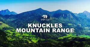
| Knuckles Range | 1,862 | Moderate | Bambarella | Matale | Google Maps |
| Pettigala | 1,500 | Difficult | Balangoda | Ratnapura | Google Maps |
| Waulagala | 900 | Easy | Amanawala | Kegalle | Google Maps |
If you’re interested I’m going to lay out some background information about mountains in Sri Lanka. Get a hearty cuppa and read along.

On the way to Manigala, Knuckles forest reserve.
FYI Some of the mountains are restricted to the public due to security and environmental protection. Let’s get to know them first.
Restricted Mountains

Hakgala mountain, with its three distinctive peaks – Photo Credit: Holiday Trail Ceylon.
The highest peak of the island, Mt. Piduruthalagala (2,524m) is restricted for hiking purposes. But the summit can be reached by a vehicle after obtaining permission.
By the way, the highest peak that can be climbed is Mt. Kirigalpoththa (2,388m). It is located within Horton Plains NP and can be climbed without much trouble.
Hakgala (2,170m) is another restricted peak. It is situated within a strict nature reserve hence not accessible to the public. The Hakgala botanical garden is located at the base of this giant.
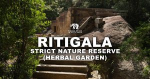
Ritigala (768m) is another mysterious mountain that is not allowed for hiking due to the sensitive environment. It can, however, be explored for research purposes after obtaining permission from DWC.
In case you’re wondering, there are no Volcanoes in Sri Lanka.
Sri Lanka has 03 major massifs (Group of mountains)

Hanthana mountain range – A popular hiking trail among Sri Lankan university students.
- Central Highlands – The hill country packs the highest peaks and covers an area spanning 20% of the entire island. Central hills area serves as the major catchment area for almost all the rivers. It is also a UNESCO world heritage.
- Knuckles Massif – Knuckles forest reserve is unique for its rich biodiversity. This serene forest cover is adorned by some 30 summits and many waterfalls.
- Rakwana-Deniyaya Massif – The smallest massif of the island is located in the southwestern region of Sri Lanka. These are smaller and lesser explored peaks so If you wanna try discovering things, here is the area.
In addition to these, there are standalone hills (Erosion remnants) and rocks strewn across the northern and eastern plains.
Sigiriya, Ritigala, Athugala to the north and Thoppigala, Dhanigala, Dimbulagala to the east are some example of such lone giants.

Piduruthalagala Range (Right) – Seen at Mandaram Nuwara – Photo Credit: Viranga Perera
Let’s get into the list of peaks that can be reached. After all, that’s why you’re here.
I have categorized these peaks under 04 difficulty levels. Mind you these are not internationally standardized levels, just meant to compare mountains within Sri Lanka only. Also, the levels can be subjective since I base this information on hiking reports of someone else.
Difficulty Levels: Easy, Moderate, Difficult, Strenuous
Difficulty classifications are based on various factors such as;
- The grade of the peak (slope) – There are vertical rock walls and hills that are nearly flat which your grandma could climb.
- The time it takes to complete the hike – Climbing Sri Lankan peaks may take max 2-3 days or just 01 hour. Portaledges are unheard in these parts.
- The need for technical climbing skills – Some peaks may require the knowledge of technical skills such as rock climbing, free climbing.
- Usage of ropes and harnesses – Free climbing can be deadly on some peaks.
- Weather conditions – Severe weather conditions such as wind, mist, and rain (No snow here, luckily) can make climbing difficult.
- Whether a guide is required – Popular Mountains like Adam’s Peak have well laid out paths but not so with the peaks surrounded by thick woods. You’ll need to hire a reliable local in such cases.
- Wildlife – Poisonous snakes, Wasps, Sloth Bears and Leopards can be found in some trails. But most of the time, only the leeches are there to annoy you.
You’ll notice I’ve omitted Adam’s Peak (Sri Padaya) from this list. The reason is there are 06 paths, with varying degree of difficulty, to reach the sacred summit. I’ve mentioned all those paths in my guide to Adam’s peak trails. Please check that out as well.
Important!
- The peaks marked “Strenuous” are fatal and do not attempt without a knowledgeable guide and proper tools (ropes, harnesses). It’s recommended to notify police or a legal authority before starting the hike/climb.
- Wherever you go, please be a responsible traveler and avoid/minimize the use of polythene. Bring back bring any such non-bio-degradable material with you and dispose of them properly.
It’s your move now, go explore the lofty hills of this blissful Island. Find new routes and new peaks. There are many more peaks/rocks to be climbed and those will be added in due course. I’m going to post more detailed guides on climbing above peaks soon so subscribe to our newsletters and stay in touch.
Happy Climbing!!
References
- The Central Hill Country by Sudath Gunasekara. B.A. PhD. (S.L. A. S)
- Rakwana-Deniyaya hills by Prof. Nimal Gunatilleke, University of Peradeniya
- Trip Reports Archive, Lakdasun